《TAIPEI TIMES 焦點》 Storm misses; typhoon approaches

Fishing boats are docked at the second fishing port of Nanfangao in Yilan County yesterday in preparation for Tropical Storm Linfa and Typhoon Chan-Hom. Photo: Wang Yang-yu , Taipei Times
HIGH-PRESSURE SYSTEM: CWB forecaster Fred Tsai said that as Typhoon Chan-Hom has been building over warm water, it has potential to become stronger
By Shelley Shan / Staff reporter
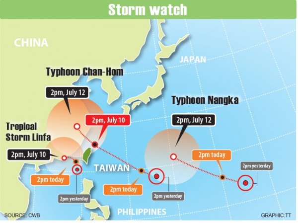
The Central Weather Bureau (CWB) yesterday lifted its land alert for Tropical Storm Linfa, but warned of the possible impact of Typhoon Chan-Hom, which is approaching northern Taiwan.
Bureau forecaster Fred Tsai (蔡甫甸) said that the land alert was lifted because Linfa moved farther west than they had predicted, making it unlikely that the storm would make landfall.
On Monday, the bureau forecast the storm would skirt the east coast without making landfall. However, Linfa yesterday changed path, with the storm forecast to hit the southwest coast.
The bureau cited a lack of a clear guiding air stream as the reason for it being difficult to predict Linfa’s path.
Despite lifting the land warning, Tsai said that waves could reach as high as 5m on the southwest coast, on Penghu and on Siaoliouciou Island (小琉球).
Meanwhile, the southern half of the nation should brace for heavy rainfall, Tsai said, adding that an alert for extremely heavy rainfall has been issued for the mountainous areas of Kaohsiung as well as Pingtung and Taitung counties.
However, Tsai said that the sea alert for Linfa would not be lifted until tomorrow morning, when the storm is projected to move away from the outlying island of Kinmen. He said the sea alert could be lifted sooner if the storm continues to weaken.
At 5:30pm yesterday, the storm’s center was 260km southwest of Oluanpi (鵝鑾鼻). It was moving northwestward toward the south of the Taiwan Strait at 7kph.
However, the bureau said that the nation should remain aware of the movement of Typhoon Chan-Hom, which is about 1,800km from Taiwan.
“Typhoon Chan-Hom is projected to affect the coastal areas of Taiwan on Friday and Saturday, and we might issue a sea alert for the typhoon tomorrow,” Tsai said.
He said the typhoon has the potential to become stronger as it has been building over warm water.
According to Tsai, Typhoon Chan-Hom is likely to move along the edge of a high-pressure system in the Pacific Ocean and is approaching the nation’s north coast.
He said that the nation’s central and northern regions would be affected by the typhoon if it continues on its projected route, adding that the typhoon has the potential to affect the whole nation if its course alters.
Meteorologist Daniel Wu (吳德榮) said that there is an increasing chance that the typhoon would make landfall in Taiwan.
“The threat from Typhoon Chan-Hom is greater than that brought by Tropical Storm Linfa, so the nation needs to pay close attention to it,” Wu said.
新聞來源:TAIPEI TIMES